In March 2011, a 9.0 magnitude eartchquake hit Japan with catastrophic results. Mapping software firm Esri turned tweets, Flickr images and YouTube posts to help people track to status of the location anfd the impact of the earcthquake, resulting in result in hundreds of thousands of page views. Adding Tweets to mapping technology gives insights into what people are saying and where they are saying it. It can highlight spatial trends in the conversation. Combining a Twitter conversation with authoritative data sources, like 911 calls, insurance claims, demographics, weather reports, and earthquake feeds, can provide a human perspective on the situation.
New Idea
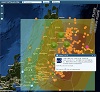
On March 11, 2011, a 9.0 magnitude earthquake struck near the east coast of Honshu, Japan. As the news broke, many turned to Twitter to get the latest updates from people on the ground who experienced the disaster first hand. Within hours of learning about the devastating event, the @Esri team used Twitter to launch an interactive map that combined trusted sensor data with Tweets and other social feeds like Flickr and YouTube. The team layered Tweets over an information-rich map that showed earthquake location, a shakemap, and aftershocks from USGS. The resulting product helped the world understand the impact of the earthquake and resulting tsunami.
Layering Tweets over its maps, Esri produced deeply engaging maps that result in hundreds of thousands of page views.
Adding Tweets to mapping technology gives insights into what people are saying and where they are saying it. It can highlight spatial trends in the conversation. Combining a Twitter conversation with authoritative data sources, like 911 calls, insurance claims, demographics, weather reports, and earthquake feeds, can provide a human perspective on the situation. By adding social intelligence to its mapping and analyzing the Twitter conversations, Esri visualizes the most engaging Tweets over space and time to get a better understanding of how a crisis event spreads and where resources are needed. Esri maps can even help predict the weather, just take a look below.
Implementation
@Esri's proof of concept uses public Tweets to tell the story of what is happening on the ground in real-time. This has been hugely successful and has allowed the team to generate more projects that use Twitter in decision making platforms for retail, public safety, and insurance customers.
Esri's Twitter mapping work began with the Twitter Search API. Although the API provided a low barrier of entry for accessing geo-tweets filtered by topic, Esri quickly realized that the quantity of information available through the Search API could not facilitate decision making. Esri turned to Twitter’s data partner Gnip to provide a source of data that they combined with their spatial analysis engine. Esri has prototyped and will switch to using the Streaming API to find Tweets for all pubic facing applications on Esri.com, like this Severe Weather Map.
Impact
The Japan earthquake map was picked up by news organizations including CNN, ABC, Al Jazeera, and Wired resulting in over 500,000 page views to the application on Esri.com in the days following the event. Typical page views for Esri.com disaster response pages are around 5,200 per week. Esri customers and partners have also had great success implementing Twitter in their maps. Esri's Spain’s map of the 2011 elections, combining demographics, polling locations, and social conversation, received 4 million requests per hour at its peak and was linked from the home page of Spain’s largest media organization.
As a side note, Esri built the Pubic Information Map application featured in the maps in this case, and encourages readers to go to ArcGIS.com to download the code and begin exploring social media mapping for workflows.